We had two options when we woke up this morning: 1) go back to sleep, eventually drive 5 hours to Bishop area, stay the night and drive the remaining 5 hours home on Tuesday; or 2) get up early and drive the 10-11 hours straight home in one day. Mike woke up, packed up and kicked Bree out of bed for option #2. We packed the car and grabbed some free continental breakfast. We were on the road by 7:56am local time. Mike set the cruise control, Bree knit and we didn't stop for five hours. We finally stopped in Barstow, east of LA, for lunch and gas. We got back on the road and headed north through Bakersfield to I-5 and all the way home. We made it home by 6pm, PST, which made the whole drive 11 hours, 10.5 hours driving.
We were happy to be home, unpack and get our puppy dog back. Bree still has loads and loads of laundry to do. Mike has to get the car cleaned, change the oil and do his best to let it recover from the long trip. We decided there were a few ways to summarize the trip:
Pictures taken:
Total for 2 digital SLRs and 2 digital point and shoots: 2244 (includes some triplicates for HDR)
Best of: 135
Injuries:
Bree: Crescent shaped sunburn on each shoulder, sprained ankle, two bug bites, one sunburned thigh from off-roading
Mike: 4 bug bites, sunburned top of feet, neck and driver's arm, singed eyelashes, eyebrows, hair and hair on fingers.
Miles Driven:
Total on car for trip: 2911 miles
Total "main road" driving: 2266 miles
Total off roading miles: 119 miles
Weather encountered:
Thunderstorms: 2 days
Rain: 2 days
Dust storm: 1 day
100+ degrees: 1 day
Freezing temperature: 1 day
Sleeping arrangements:
5 nights in a hotel
5 nights in a tent
Desert Adventure Tour 2009: Priceless
Videos still to come on www.youtube.com/MBDreyfuss
Pictures still to come at Picasa
Tuesday, June 30, 2009
Monday, June 29, 2009
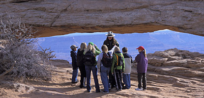
Day 10: North Rim of the Grand Canyon (Sunday)
We were awoken very early, when it was barely light, by very loud birds at our campsite. Since we knew we had to be up very early for the mule rides, neither one of us could sleep once we woke up. We had to be at the Grand Canyon Lodge at 7:25am, and we figured even from the closer campground it would take about an hour to get there. That meant leaving the campground at 6:25am. Usually it only takes about a half an hour for us to break down camp if we have breakfast in the car, but we wanted to make warm corn beef hash for breakfast which would take a little bit more time. So Bree set her phone alarm for 5:45am, local (mountain standard) time. So when the birds woke us up and it was light, we figured it was time to get up. We broke down camp and found it to be painfully cold. The whole tent was wet with dew and much of it had frosted over. We decided it was better to eat dry cereal in a warm car than warm breakfast in the cold open air.
We were packed up and headed to the entrance of the park by 6:25am. The meadows were covered by low lying clouds and much of them were frosted. We watched the thermometer in the car drop as we drove, finally settling around 33 degrees. It was very very cold outside, thank goodness for seat warmers! We got to the lodge at 7:05am, figuring earlier was better, we hung around for awhile looking for other mule riders. We had been told to meet in front of the lodge gift shop, which was off to the side of the lodge, and wear long pants. There were only a few people wandering around, none in pants and none where we were supposed to meet. The woman that had taken our money for the trip had told us to meet there at 7am if we hadn't paid yet so we figured she had to be there. We checked at the desk and no one was there either. We started to get worried around 7:30am and Bree finally asked at the concierge desk if they knew anything about the mule rides. The concierge provided the same information we had been given, meet at 7:25am in front of the gift shop, a large white van that said "mule rides" would pick us up. Bree told her thanks but it was 7:30am and there was no one there. The concierge calmly explained (although you could tell she was tired of doing so) that the Grand Canyon was on Arizona time, which is Mountain Standard Time, but, Arizona doesn't observe Daylight Savings Time. Which means when we thought it was 7:30am, it was 6:30am. So that meant that not only had we waited around for a half an hour, we were still an hour early!
We were cold, having not brought a sweatshirt thinking it would warm up, so we went back to the car. Mike read his book and Bree played her DS Scrabble for an hour or so in the warm car. By the time we headed back, there was a large group of long pants wearing tourists talking about mule riding. And sure enough, there was a large white van that said "mule rides," by Canyon Trail Rides. A young boy and a man in full cowboy gear (stetson, cowboy boots, chaps, plaid shirt and vest) welcomed us and got us into the van. On the way to the trail head we heard a recorded safety message about how to ride the mule and what not to do. Mike was nervous the whole time, he had never been on a horse or a mule and wasn't sure about it.
We road to the North Kaibob trail head, the only trail that goes into the canyon from the north rim. The mules were hitched up in a pen and were larger than we had expected. Mules are sterile offspring of horses and donkeys. They have attributes of both that are advantageous for trail guiding. Apparently the larger ears of a donkey help to let heat dissipate, like rabbit ears. Mule eyes are also oriented like a donkey's which allow the mule to see all four of its feet at the same time. Their shoulders make incline walking easier for them than horses. They can live over thirty years to forty years and even though they may want to stop pulling large loads in their twenties, like many work animals, they have to keep working at least a little or they will die soon after retirement.
We were split into two groups and the main guide sized us up to pair us with the "right" mule. It is tricky because they wanted to keep groups together, so they had to be mindful of what mules followed/ led other mules well. And they had to put the right mule under each person. There were easily 50 mules and the guides knew the names of all of them and their personalities. "You'll get Flex, you on Fred. You've ridden before? You get Woody," etc. Mike and I were at the end, Bree was given Blue and Mike was given Dolly, both female. We were helped up and told how to steer the mules. The mules are specifically trained on the trail and can follow each other down without rider assistance, but they like to have you back up the training. You pull the right hand rein to steer right, and the same for the left. Pulling back on both means stop. You were supposed to lean back in your seat with your toes pointed up and your heels down on the way down the trail, then lean forward on the way up. If the mules were falling behind, you had to kick them with both heels. It was dangerous to fall too far behind the other mules because then they would want to catch up eventually and trot too fast.
As we started down the trail, we each paused for our souvenir photograph. It was tough at first, until we got used to being in the saddle. At the head of the North Kaibob Trail there is a large sign that warns hikers that if you come upon mules, wait to the right and listen for instructions from the mule guide. It was a large sign, one would think you couldn't miss it.
We started down the trail, it switchbacks all the way down into the canyon 2300 feet to the Supai Tunnel. On the way down, Bree had the video camera and Mike had the small (durable) digital. We were the last two mules in the train and Mike's mule Dolly had trouble keeping up. The guide actually had to come tell Mike to be more stern with Dolly to make her keep up. After that she was better. The view on the way down was amazing, we took video, you could clearly see the change in the rock layers along the trail. Our guide stopped us ocassionally to show us formations and tell us facts about mules.
If you aren't always around large animals, you forget about the smells and bodily functions. Like horses, mules poop anywhere and alot. It was strange to look down on the trail, knowing that other visitors would walk down the trail. And as we came around one corner, a mule in front of us started to pee. The term, "I have to pee like a horse," is based on fact as far as we can tell. It was odd to see a mule spread its legs and drop a few gallons. It was quite a surprise when we saw the next mule stop and do the same, then a few mules didn't, then another one did. At most corners, at least two would pee and create a mud puddle you would want to avoid. Later, our guide told us it was prey animal behavior. We thought it was like a dog, marking territory, but that is predatory animal behavior. Apparently prey animals will hold it until they cross a point where they smell another of their own and then they will pee there. That way they are able to hide their numbers from predators. The guide told us that this is something they cannot help and you just have to wait til they're done.
We continued on the trail and crossed a few hikers. The first couple came up on us, luckily, when we were stopped. They walked past, carrying supplies and startled the lead guide's mule. We had been told not to remove hats or jackets without someone holding the mule because they can easily startle. Since they are prey animals, they are naturally paranoid and will run when anything flashes in front of them. The lead guide's mule was being trained and was young, it was particularly startled by the camper's water jug, which was sloshing and making all kinds of noise.
We continued past Coconino Point, where most easy day hikers turn around, to Supai Tunnel. The trail continues to Supai Tunnel, which was blasted through when the trail was first blazed to reach the water down in the canyon. Its farther down, 1.8 mi down the trail, a 1450 feet elevation change, and would make a tough hike. There was a place to hitch the mules so we could get down and get some pictures and water. Our guide took us through the tunnel to show us the view of canyon and see the rest of the trail. There is a bridge that the guide said a lot of inexperienced hikers try to make it to and back in a day and often get stuck on the way back up. Some marathon and triathalons runners train on the trail and one holds the record for the fastest time from North Rim to South Rim of 3 hours and seven minutes.
We let the mules rest and then headed back up. We had to stop a few times to let the mules rest, uphill is harder than downhill for them just like us. When we stopped, we were able to take pictures. On the way up we were also introduced to another large animal behavior we weren't used to, flatulence. The entire way up was like our very own wind ensemble. Apparently Mike's mule had had that problem the entire way down but no one had heard because he was in the back. It made it even more uncomfortable for hikers following us.
As we got up to the top of the trail, we dismounted and thanked our guide. We were given official looking certificates that we were "muleteers." We also got our souvenir photographs on the bus of us and our mules. We road back to the lodge and got to our car around 11am. We headed straight to Zion National Park.
It took us only about two and a half hours to get Zion National Park, back in Utah so we had to switch our clocks again. We entered from the East exit and had to wait in a long line at the park entrance. As we waited, we tuned into the AM station for park information. It turns out they have implemented a shuttle for the most popular road in Zion, and you cannot drive your own car on it. We followed a large line of cars down a single lane each way winding in and around rock formations. We learned later we were on the Carmel Highway, and it is quite a road. It was built in the 20's and has a mile long tunnel through solid sandstone. There are amazing views along the way but not a lot of places to stop. Along the way, we saw what we thought was a mountain goat on the side of the road. Later we realized it was probably a big horn sheep, which Mike had wanted to see the entire trip. He would often jokingly call for them on hikes, saying "Bbbbaaaa" as we walked. The road switchbacks as it lowers your elevation and you finally come to a T in the road. To the north is the Zion Canyon Road, which only shuttle buses are allowed on, and to the south is the visitor center, a museum and the south entrance.
We went to the south to stop at the Visitor Center and barely found a parking place. Apparently, in the summer it is often so packed that you cannot park in the park itself and have to park in a nearby town. There is a separate shuttle bus that goes to the town and back all day. We found a spot and were instantly hit with the typical tourist of Zion park. It was a whole family of large boisterous people complaining of heat, walking, each other, parking, etc. We tried to get as far as possible from them and headed to the visitor center. The visitor center is environmentally oriented and was specifically designed to take advantage of the seasonal changes at Zion. It has this amazing baffle tower system with water in it that cools the inside in the summer and keeps it warmer in the winter.
We got our stamp in the passport book, our last one of the trip and it was only then that we realized some of our stamps were in the wrong section. Utah was in a different section from Nevada and Arizona. It bothered Mike that they were in the wrong section so we plan on scanning and pasting them in the right spot.
From the visitor center we got onto a shuttle and headed north into Zion Canyon. There are several stops for hikes and exhibits. It was over 100 degrees and being late in the day, we decided not to do any longer trails. Like the Grand Canyon, there were a few hikes less than a mile and a bunch over 5 miles. The shuttle had a prerecorded narration that pointed out sights and gave us a bit of history on the park. We got off at the Court of Patriarchs and took a short (100 yards) hike to the view point. The Patriarchs are three large mountains named Abraham Peak (6890ft), Isaac Peak (6825ft), and Jacob Peak (6831ft) – named for three towering figures of the Old Testament.
We got back on the shuttle and headed north to the Weeping Rock stop. There was a short hike, a mile round trip, up to the Weeping Rock. Its half a mile straight up, with stops along the way with flora and fauna signs. There were wild grape vines, and variations of oak and maple. When we got to Weeping Rock, we learned that it was sandstone above and shale underneath. Water went through the hundreds of feet of sandstone above because its porous and when it hits the shale, which is not porous, the water seeps out along the horizontal barrier. Experts say that the water took 1,200 years to move through the sandstone! The water gets all over everything, so there are handrails everywhere. On the way down, Bree had to walk behind a guy that stopped on the stairs. She tried to step to the side and ended up stepping right into a large divet on the stairs, spraining her ankle. The hike back down was a bit slower, Mike called her gimpy.
After we got back to the shuttle stop, we continued on the shuttle north to the very last stop in the Zion Canyon. The Zion Canyon narrows at the north end and if you follow the Virgin River up into the north end of the canyon its called the Narrows. We took the shuttle back south, each of us on a different side of the shuttle so that we could get pictures of everything. We stopped at the museum on the way back and watched a short video on the park and its history. Apparently, everything had an original Native American name until the Mormon settlers came and renamed everything. Other names that were not biblical, were definitely not accepting in nature. For example, the Altar of Sacrifice, is a large mountain that has distinct red stains on the side from water filled with iron. But the Mormons named it as such thinking the Native Americans sacrificed on the peak. All the renaming annoyed Bree.
We got back to our car around 6:00pm, and were quite done with Zion. It was very commercial and very busy. It was hot and with Bree's ankle we couldn't hike anything. We gave up and decided to go to our hotel. We plugged the address into our GPS and were surprised that it said we would arrive at 6:20pm, considering it said it was 6:18pm. Turns out, if you go out the south exit, you are immediately in the neighboring town of Springdale. Springdale is where we were told to park and catch the shuttle if we couldn't find parking. It was less than a mile to our hotel from the visitor center.
Mike got us checked in and we went up to our room to settle in. Bree blogged and uploaded some pictures as she iced her ankle. We showered and headed downstairs to a burger shack attached to the hotel. The owner had just opened and was originally from Vacaville, so he knew where we from. The food was great and the owner was great, always checking on us. It seemed like his business was going well because as we were finishing up, over a dozen teenagers came in and racked up a huge order.
We went back up to the room and relaxed as Bree iced her foot. We're undecided if we're going to try to head back in one day or make it two.
Sunday, June 28, 2009
Day 9: North Rim of the Grand Canyon (Saturday)
We woke up early and broke down camp. We weren't sure if the other campground we wanted was full or not so we thought we'd pack up just in case. It takes about an hour to get from Jacob Lake to the entrance of the park. On the way we drove through lots of meadows. After we got into the park we saw more meadows, one with bison in it! Apparently, Bison are called "bison" in the US but should be referred as "buffalo" if they're in Asia or Africa. We wanted to stop to get more pictures but didn't think we should. Later in the meadows we saw deer (not sure if it was common deer or mule deer) that started prancing. They looked just like Bree's parents' dog, Zoey when she prances. The main park road splits into a Y shape, off to the West is the main lodge and off to the East are some view points. We went to the lodge first, the Grand Canyon Lodge at the North Rim reminded us of the Ahwanhee hotel at Yosemite National Park. People that stayed there wanted paved trails and access to gourmet food. We visited the Visitor Center to buy postcards and get our stamp and to check about trail conditions.
We decided to take the Bright Angel Point trail, only about a half mile but nearly straight up along a rock outcropping from the point the lodge was on. It was pretty steep, although short. It ended right on the edge of the rock. We saw one tourist climb over the fence to go a little bit farther out to pose for a picture. Silly people. We took pictures and took the other half of the trail back to some other fenced outcroppings below the hotel. They had some great views of the canyon. From there we headed back up through the lodge towards the car. There was a bronze statue of "Brighty" the donkey. Apparently, Brighty was a donkey at the Grand Canyon that was popular with children and tourists, met the President and a children's book was written about him.
We went back to the car and headed back up the road to check in at the campground to see if they had any space. The ranger didn't quite laugh at Bree when she asked but apparently it fills up way in advance. So we continued on the road and Mike found a 4x4 road he wanted to take out to Point Sublime. Usually, we check with the Rangers for road conditions, suggestions, and to see if the Subaru can make it. We didn't because we didn't know it existed until after we left the visitor station.
The first portion was just unpaved, any car could have made it. Then we hit a sign that suggested only 4x4 vehicles with high clearance should continue the next 18 miles of the road. Bree was hesitant, Mike wanted to go. It was a great ride, up and into the forest. At times the road was only as wide as the car. We traveled from open grassy meadows to dense pine forest mixed with aspen. The aspen is called Quaking Aspen and is so named because with any wind the wide leaves move and make the trees look like they are shaking. The road went up and down many hills and we reached a total elevation of 7400 feet, best we can estimate. The road wasn't actually shown in its entirety on the park map so we had to look over some satellite photos and an offroading site to try and find the point. It was way out there! The road was technically very difficult and Mike had some trouble. There were quite a few points that Bree was sure we'd get stuck on. The road was rough and rocky, with large boulders to maneuver around while going up a steep grade. But we finally made it and Point Sublime fit its name. It was totally isolated and we had the whole point to ourselves. It was very high up and gave a great view. We wandered around and had lunch out there at a picnic table. Someone before us left an entire 30 pack of Coors Light Beer up there. Mike said it was water and wasn't worth taking. We headed back down the road, which was a lot easier when Mike let a little air out of the tires. It ended up taking about 3.5 hours by the end of it to go 36 miles of rough off-road.
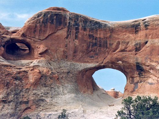
When we got back to paved roads we continue to the Y-intersection and headed the other side of the north rim. It took about 45 minutes to get to the end of that branch of the road. It dead-ends at Cape Royal, where we took another short hike. It was only 0.6 miles round trip and paved. Still, we heard tourists (the same ones that had climbed the fence at Bright Angel actually) complain that this was how trails were supposed to be, not like that dirt trail they took earlier. Along the trail there were several spots to go right up to the canyon edge for viewpoints. One of the best was of Angel's Window, which is an easily seen arch in the park. The trail continues so that you can walk out on the rock that Angel's Window is in. Along the way there were several explanatory boards for the flora and fauna of the area.
We got back in the car and headed up the way just a little bit to take a short hike to Cliff Springs. It was a mile roundtrip, straight down there and straight up back up. It was nice and cool because it was into a smaller canyon. You end up walking under some overhanging rocks to the spring. As soon as you step onto the rocks there was a large sign that warned against damaging the rocks, marking them or moving them in any way. We wondered why until we got to the spring. Apparently, visitors like to grind up some of the red sandstone, get it wet and use it to make red handprints on the lighter colored sandstone above their heads. The whole spring area is now covered in red handprints. We walked around for a little bit before heading back up the hill. We continued on the road back towards the Y and stopped at a few overlooks on the way, including a short road up to Point Imperial. "Point Imperial, the highest point on the North Rim at 8,803 feet, overlooks the Painted Desert and the eastern end of Grand Canyon."
From there, we headed back to the Y-intersection and towards the park entrance. We had done everything we could for the day. Most hikes are either super short or super long. It was way too late in the day to start a long one. As we exited the park, we saw Bison again. About halfway between the park entrance and Jacob Lake was another Kaibob National Forest Campground called the De Motte Campground. We wanted to camp there for the night so that it wouldn't take us so long to get back to the North Rim in the morning. Luckily they had room, same set-up as last night so we picked a spot and got set-up. We made macaroni and cheese and hot dogs for dinner which was quite yummy. Mike read and Bree played Scrabble on her DS before it got too cold and she went into the tent. We went to bed early because we had a mule ride early in the morning!
We decided to take the Bright Angel Point trail, only about a half mile but nearly straight up along a rock outcropping from the point the lodge was on. It was pretty steep, although short. It ended right on the edge of the rock. We saw one tourist climb over the fence to go a little bit farther out to pose for a picture. Silly people. We took pictures and took the other half of the trail back to some other fenced outcroppings below the hotel. They had some great views of the canyon. From there we headed back up through the lodge towards the car. There was a bronze statue of "Brighty" the donkey. Apparently, Brighty was a donkey at the Grand Canyon that was popular with children and tourists, met the President and a children's book was written about him.
We went back to the car and headed back up the road to check in at the campground to see if they had any space. The ranger didn't quite laugh at Bree when she asked but apparently it fills up way in advance. So we continued on the road and Mike found a 4x4 road he wanted to take out to Point Sublime. Usually, we check with the Rangers for road conditions, suggestions, and to see if the Subaru can make it. We didn't because we didn't know it existed until after we left the visitor station.
The first portion was just unpaved, any car could have made it. Then we hit a sign that suggested only 4x4 vehicles with high clearance should continue the next 18 miles of the road. Bree was hesitant, Mike wanted to go. It was a great ride, up and into the forest. At times the road was only as wide as the car. We traveled from open grassy meadows to dense pine forest mixed with aspen. The aspen is called Quaking Aspen and is so named because with any wind the wide leaves move and make the trees look like they are shaking. The road went up and down many hills and we reached a total elevation of 7400 feet, best we can estimate. The road wasn't actually shown in its entirety on the park map so we had to look over some satellite photos and an offroading site to try and find the point. It was way out there! The road was technically very difficult and Mike had some trouble. There were quite a few points that Bree was sure we'd get stuck on. The road was rough and rocky, with large boulders to maneuver around while going up a steep grade. But we finally made it and Point Sublime fit its name. It was totally isolated and we had the whole point to ourselves. It was very high up and gave a great view. We wandered around and had lunch out there at a picnic table. Someone before us left an entire 30 pack of Coors Light Beer up there. Mike said it was water and wasn't worth taking. We headed back down the road, which was a lot easier when Mike let a little air out of the tires. It ended up taking about 3.5 hours by the end of it to go 36 miles of rough off-road.
When we got back to paved roads we continue to the Y-intersection and headed the other side of the north rim. It took about 45 minutes to get to the end of that branch of the road. It dead-ends at Cape Royal, where we took another short hike. It was only 0.6 miles round trip and paved. Still, we heard tourists (the same ones that had climbed the fence at Bright Angel actually) complain that this was how trails were supposed to be, not like that dirt trail they took earlier. Along the trail there were several spots to go right up to the canyon edge for viewpoints. One of the best was of Angel's Window, which is an easily seen arch in the park. The trail continues so that you can walk out on the rock that Angel's Window is in. Along the way there were several explanatory boards for the flora and fauna of the area.
We got back in the car and headed up the way just a little bit to take a short hike to Cliff Springs. It was a mile roundtrip, straight down there and straight up back up. It was nice and cool because it was into a smaller canyon. You end up walking under some overhanging rocks to the spring. As soon as you step onto the rocks there was a large sign that warned against damaging the rocks, marking them or moving them in any way. We wondered why until we got to the spring. Apparently, visitors like to grind up some of the red sandstone, get it wet and use it to make red handprints on the lighter colored sandstone above their heads. The whole spring area is now covered in red handprints. We walked around for a little bit before heading back up the hill. We continued on the road back towards the Y and stopped at a few overlooks on the way, including a short road up to Point Imperial. "Point Imperial, the highest point on the North Rim at 8,803 feet, overlooks the Painted Desert and the eastern end of Grand Canyon."
From there, we headed back to the Y-intersection and towards the park entrance. We had done everything we could for the day. Most hikes are either super short or super long. It was way too late in the day to start a long one. As we exited the park, we saw Bison again. About halfway between the park entrance and Jacob Lake was another Kaibob National Forest Campground called the De Motte Campground. We wanted to camp there for the night so that it wouldn't take us so long to get back to the North Rim in the morning. Luckily they had room, same set-up as last night so we picked a spot and got set-up. We made macaroni and cheese and hot dogs for dinner which was quite yummy. Mike read and Bree played Scrabble on her DS before it got too cold and she went into the tent. We went to bed early because we had a mule ride early in the morning!
Day 8: Canyonlands, Needles District and on to the Grand Canyon (Friday)
We left the hotel and headed way out in the middle of nowhere to get to the Needles district of the Canyonlands National Park. It took about an hour and a half and it wasn't until we got there that we realized it was nothing like the Island in the Sky. The visitor center was small and didn't have a lot of information. There is little "scenic drive" in the Needles District and few short hikes. We did the Roadside Ruin hike which was only a third of a mile and led to an ancient Native American granary. Apparently it was a common thing in the area to create a mortar and stone granary to store fruits, vegetables and seeds. They often had openings only in the roof and are still fairly complete today. From there we drove around a little more trying to find other small hikes, but the rest didn't appeal to us.
Mike found a 4x4 road to Elephant Hill and we decided to take that. It was only about 5 mi in and not too rough. We couldn't continue on the last part because it had extreme caution signs. Basically if we didn't have a lifted jeep, we weren't going to make it. Luckily, the road let us actually see the famous needles the park is named for. They were way off and there were "mushrooms" in front but we still saw them. We headed back to the visitor center, passing the only outlook in the whole park.
From there, we headed straight to the Grand Canyon. We were warned of thunderstorms and kept a careful watch on the storm clouds we could see to the west. Bree took anti-nausea medicine again and so was in and out of sleep. At one point when Bree woke up Mike was steering the car carefully through really rough winds. Another time, there was a painted wild (?) horse on the side of the road. The last time Bree woke up it was because the rain was so loud. All of a sudden, Mike found himself in the middle of a fierce thunderstorm. It cleared up and we continued across more desert. All in all it took about seven hours to get to the North Rim of the Grand Canyon's closest town, Jacob Lake.
Jacob Lake is a small tourist town at the corner of the main highway and the road down to the North Rim. Its over 40 miles from this intersection to the North Rim and the campground there fills up way in advance. So we decided to camp at the campground maintained by the Kaibab National Forest up at Jacob Lake. The campground was nice, potable water and pit toilets and we were able to pick our place. We had our leftover spaghetti which was good. It seems everywhere though that you can't wash your hair or dishes. So Mike had to fill the pot with some water, walk somewhere else to wash it with soap and the sponge, go dump it, walk back to rinse it, repeat. We had also grabbed s'mores supplies so we lit the stove up again and made ourselves some s'mores. Mike had to search everywhere for the "right" stick to whittle down for our s'more stick. We went to bed early to get a jump on tomorrow!
Friday, June 26, 2009
Day 8: Moab, UT to Grand Canyon, AZ
We're all packed up and ready to go! We got to bed late because Bree was trying to upload pictures, and we're up early to get a head start. We're heading to see the Needles District of Canyonlands National Park and then a long drive to Jacob's Lake, a town near Grand Canyon where we plan to camp. The storm hit last night but seems to be moving northeast of us. Wish us luck!
Thursday, June 25, 2009
Day 7: Canyonlands (Thursday)
Today we got up around 8:30am and headed out to Canyonlands National Park, Island in the Sky District. There are three districts to Canyonlands National Park, the Island in the Sky in the North, the Maze to the West and the Needles to the Southeast. The districts are separated by the Colorado and Green Rivers and you cannot cross from one to the other within the park. We stopped by a local grocery store to buy food for the next few days and finally got some essentials, like a flashlight, a sponge and dishwashing detergent. We drove to Canyonlands and got to the visitor center around 10am. There is no water or any other services available in the park. It is a very rough park, not a lot of small hikes or excursions but a ton of 4x4 roads and backcountry trails. We drove along the main road (Y-shaped) and stopped at the outlooks. We did a 0.5 mi hike to Mesa Arch which was quite impressive. It is way up on a bluff and you can see the valley below it.
From there we drove down the scenic drive and stopped at more outlooks until it dead-ended at Grand View Outlook. It was a great view of part of the canyon below, Monument Basin. From there, we took a 2 mi round-trip hike along the Grand View Outlook Trail. It was a long trail but it was not too much of an elevation change, we were already pretty high up. The whole trail was right along the cliff edge across sandstone and rock outcroppings. As we followed the Cairns across the rocks we could see dark clouds coming from the southeast and could hear distant thunder. We continued on the trail, wondering when it would end since it wasn't a loop, until we came straight to a cliff. That made it obvious that this is where you turn around. We could see a large rock monolith straight in front of us and found out later that it was Junction Butte. The storm was getting closer and we were starting to see lightning so we tried to hurry back. Of course, on the way back we were tempted by the lightning and tried to get some video and stills of the lightning flashes. When we got back to the car we were pleasantly surprised that the storm had past the bluff we were on. But that whole side of the Island was dark with storm clouds.
We left the outlook and headed back to the Y in the road and headed in the other direction, away from the clouds. We stopped at a few outlooks and at the end of the road we got out to hike the Upheaval Dome. The Upheaval Dome is actually a huge crater, 2 mi across and 3/4 of a mi deep. At the bottom of the crater are "mountains," athough we don't know if they're tall enough to actually be called mountains. There were several trails available from there, one all the way around the crater, a 0.8 mi roundtrip to the first outlook and 1.8 mi to the second outlook. We headed up and at the top of the hill at the first outlook there were explanatory boards as you looked into the crater. There are two theories as to how the crater formed: meteorite vs. salt dome. The meteorite theory requires a meteorite to have fallen nearly straight down and the ground to recoil afterwards. The dome was built by the recoiling earth, it would have been eroded down into the mountains we see today. The Salt Dome theory is harder for the average visitor to take in. Layers of salt laid down by ancient seas were covered with sediments and squished under pressure. Turns out, salt is almost plastic under pressure and because it is less dense than the sediment above it started to rise and created a dome shape that pushed the sediment into the same shape above. Then the dome eroded down into the mountains. We ran into a ranger up there who told us the third theory is that it is an alien spaceship blast-off zone, or at least that's what she tells visitors. She said that was more accepting for many than the other two. She told us the second outlook wasn't too much better than the first so we decided to head back down.
From there, we headed back towards the other branch of the Y to exit past the visitor center. The entire east side of the park was dark with storms. On the way home the radio was interrupted with severe thunderstorm warnings for most of Utah. We didn't think our county was affected. When we got back to the hotel, we checked NOAA and it looks like 40% rain over the next few days from Moab to the Utah/ Arizona Border. Chance thunderstorms the whole time and when we're in Grand Canyon. We're going to have to play it by ear tomorrow. We plan on driving down to the Needles section of Canyonlands. We figure touring there won't take too long as there is little roadway that doesn't require a 4x4 jeep. From there we'll drive to the Grand Canyon and hopefully make it before the storm and/ or dark.
Wednesday, June 24, 2009
Day 6: Delicate Arch (Wednesday evening)
We tried to take a short nap to prepare for the Delicate Arch Trial. Mike slept but Bree was bothered by the noisy upstairs neighbor. We don't know what he was doing but he seemed to either be jumping up and down on the bed or stomping around the room. Either way, Bree didn't nap. We got up around 5pm, grabbed a sandwich and headed back to the park. A lot of people were leaving the park but we were surprised when we got to the Delicate Arch Trailhead to see so many cars. By the time we lathered on the sunscreen and packed the bags (telephoto lens + ultra wide lens + video camera + 3L camelback backpack + SLR camera with wide lens + small digital camera + 3 x 1L water bottles + tripod) we hit the trail around 6pm. Luckily, the sun was going down and in and out of clouds, tt was still mid 90's though. The trail was 1.5 mi straight uphill. The first 0.5 mi is "defined trail" and after that the guide said "the trail becomes less defined, follow the cairns along the slickrock." Cairns are small piles of rocks that the National Park uses to indicate the path. There is special soil in Arches, which is very fragile, "Biological soil crust or "cryptobiotic soil" (bacteria, moss, lichens, fungi, and algae) grows everywhere except on rock." So it is very important to stay on the maintained trails as footsteps can damage decades of growth and take just as long to recover.
We headed up and it was a tough 1.5 mi! Bree had to stop often, although not tired, the elevation made breathing harder. We made it to the slickrock which was odd to hike on. It has a barely visible path and is just a large expanse of domed rock. We passed lots of people coming back down, elderly folks and young kids, so we figured if they made it we would be able to. We finally hit the leveling off point high in the rocks and followed a 200 ft section along the rock edge before we turned the corner to see the arch.
It was quite amazing. Delicate Arch stands alone in front of a large depression. It is quite a large arch and the hole in front of it creates an ampitheater shape around it. There were dozens of people there when we made it up. Surprisingly it only took us 50 minutes to reach the top. There were professional photographers all set up and waiting for sunset and lots of amateurs. There was a sign at the head of the trail that warned against being an "arch hog." Lots of people wandered down there to take pictures in front of the arch, some were slower than others but it was a seemingly endless stream of people. All the professionals had to wait to snap a quick picture as people exchanged spots under the arch. Mike went up on a ledge and had to wait almost a half an hour to get the shots he wanted. Bree grabbed the camera and climbed down into the bowl and around to the other side of the arch. The pictures were quite amazing from both spots. As Bree climbed up on a rock to get a different angle, the lens cap fell off and began to roll away, she was sure it was headed over the edge but luckily it turned and didn't make it all the way down. As we were waiting for the light to change at sunset, we took some self-portraits in front of the arch and relaxed. There were quite a few "nature enthusiasts" that climbed up on high ledges and hoodoos to get different views. There was also a large Raven that begged for food and got quite close to people, almost like he was posing. Bree managed to snap some photos with the Raven in the foreground and the arch behind him.
As it got later, the light changed and Bree headed back down into the bowl to try and get some more shots. Not so patiently waiting for some Japanese tourists who were hogging the arch, Bree managed to be in just the right spot as the sun finally made it out from behind some clouds. While the arch was lit, you could hear everyone snapping away and Bree climbed around the bowl clear to the other side so as not to miss an angle.
We finally headed down around 8:15pm. The light was going to just get worse and we didn't want to try to traverse the trail in the dark. We were surprised how many people were on the trail heading up. Some looked like they couldn't physically make it up the trail, and definitely wouldn't make it while the arch was still lit. On the way down we kept telling people how much farther they had, kind of hoping they wouldn't try to get up there and back in the dark. One couple didn't seem like they were going to make it and said they had two girls following them. Farther down the trail we found them and tried to encourage them to catch up with their folks. The girls said they could do it but just hadn't expected to go on this hike. We noticed they had no water and we asked if their parents had any. They said no so Bree suggested we give them one of our old water bottles. The Rangers suggest two liters of water per person to do the trail and this family of four had none! We gave them a liter bottle and since it was cooler it should last them. The girls were really thankful. We headed back down the hill, finally reaching the bottom a little before 9pm. There was a short hike off the main trail that took you to Ute Petroglyphs. Bree really likes petroglyphs now and was quite excited. Because it was almost dark we had to set up the tripod but managed to catch some shots.
When we got back to the car, it was still in the low 90's. We headed back into Moab looking for dinner. We stopped at a little Mexican restaurant called Miguel's Baja Grill right before they closed. We got in at 9:45pm and they closed at 10pm; by the time we left we were the only customers. The food was really good and the margarita's weren't half bad. We even have half of Mike's M.O.A.B. (Mother Of All Burritos) mixed in with the remains of Bree's Portobello fajitas for tomorrow.
Now we are full, have rinsed off our layers of dust, sand and sunscreen and are heading to bed. Tomorrow we're heading to Canyonlands!
Day 6: Arches National Park (Wednesday)
We didn't get up as early as we wanted to but we ate breakfast and were on the road by 8:30am. We had breakfast buffet next door at a Chinese Restaurant; it was strange to have breakfast sausage, omelets, potstickers and fried rice all on the same plate. We grabbed more ice, gassed up and headed to the park. Mike checked with the rangers about the off-road trail we wanted to take and was disappointed to hear that part of it was really off-roading and required 4x4 jeeps lifted for extra clearance. So we headed north on the main road and hit the Delicate Arch viewpoints, which are supposed to be best in the morning. The trailhead for the Delicate Arch trail was there and absolutely packed! We had read that the trail was best in the afternoon/ evening so we were surprised to see so many people attempt it early. It was a mile roundtrip, up to a tall rock cropping to the viewpoint to see Delicate Arch from about a mile away. The viewpoints let us see Delicate Arch but we'd still like to get to the arch itself later.
We drove north some more and stopped at a few viewpoints along the way. We went to the end of the road at Devil's Garden and prepared for the long hike to Landscape Arch. It was 10:30am, and already 95 degrees outside so we packed the Camelback backpack (3 L) and a loose water bottle (3/4 L) and all the camera gear. The trail was 2 mi round trip and we took some extra excursions to see Tunnel Arch and Pine Tree Arch (way cool link!) on the way back. We ran into the motorcyclists we met in Capitol Reef, they're camping outside of Moab. It was a hot hike but managable if you stay hydrated. We went back to the car and had a snack before heading south.
We stopped at a viewpoint to walk to Sand Dune Arch (0.5 mi roundtrip) which got its name from the thick sand you have to walk through to get to it. Its nestled inside a canyon and is fairly hidden. From there we decided to take the "short" version of a hike to the nearby Broken Arch, so named because of the huge crack in it. It was 0.6 mi in across the desert plain, as long as the wind kept up it wasn't super hot but as we got closer to the rock formations the temperature rose up. We got to Broken Arch and took some pictures but didn't continue the trail, which goes to a nearby campground. Mike climbed up through the arch to get some pictures from that side before we continued the 0.6 mi back. By the time we got back to the car we were pretty tired. We drove a little ways further to see Skyline Arch (Mike viewed it from the car) and then continued south back towards the hotel.
We got back around 1pm, ate a quick snack and showered. We're going to try to take a nap and relax since its the hottest part of the day. We want to go back and hike Delicate Arch later today, around 5pm or 6pm when its cooler. We'll see how we feel ;)
Day 6: Arches National Park (Wednesday morning)
We're heading out back to Arches. We're planning on doing the rest of the main road and see a few of the larger Arches. We're going to hike to Landscape Arch and Devil's Garden, take a four wheel drive to Tower Arch and maybe do the big hike to Delicate Arch. That's the super famous one that is all over everything that says "Utah." Its a harsh hike and is best done in the afternoon/ evening so we'll see if we make that or the overlook that's easier. Lots of sunscreen and water today!
Tuesday, June 23, 2009
Day 5: Capitol Reef to Arches National Park (Tuesday)
We got up early (again) and packed up the car and tent. Mike discovered a nice red rectangle on his foot; the top of his foot got sunburned and his sandles made an odd pattern. We haven't really "bathed" since Saturday, although we did clean up the best we could with washclothes and the sinks at campgrounds, where washing was prohibited. We knew we were going to spend a few hours in the car so even if we were clean, we'd feel like a shower by the end of it. We said goodbye to our fellow campground neighbors and headed up to the visitor center on our way out. We ate our breakfast scones (they were yummy) and continued on 24 through the valley once more. We traveled through typical Utah scenery, flatlands with short scrubby bushes with occassional mountain ranges of bare rock. We got to Arches National Park at 10:30am and it was packed! It seems as popular as Yosemite; the visitor center is huge! It was really nicely done with a nice theater and short film. They have a great set of exhibits outside with bronze sculptures of big horn sheep and other critters. There were signs everywhere warning of water dehydration and had lots of potable water spigots everywhere. We grabbed our maps and headed up the main park road.
There were a few stops along the way, like Park Avenue with the large cliffs on either side that are reminiscent of city skylines. There were also large solitary monoliths like the Courthouse, the Organ, the Three Gossips and Sheepshead. There are arches hidden along the main cliffs everywhere, and every one has its own name. We continued up the road to see Balanced Rock and walked around it. We took a lot of pictures of it as well as arches and formations in the distance. Mike had to wait awhile to get a shot without tourists climbing on it. Mike is trying a new technigue called HDR (High Dynamic Range) which takes one shot at normal white balance, one at +3 and one at -3 to be digitally combined later.
We continued on a side road past Balanced Rock towards the Garden of Eden, a large collection of monoliths. From there we continued to the Windows area, with the famous Double Arch. There is a short hike to the North, South and Turret Arches. There were so many people climbing on the arches, we couldn't get the iconic empty arch shots we wanted. We were able to take quite a few pictures though. We ate lunch there before heading over to the Double Arch trail. It was very warm and we tried out our new Camelback to stay hydrated. Tired, sunsoaked and definitely dirty, we headed into Moab in the early afternoon. Everything is outdoors- and park-oriented in Moab; most businesses are on "Main Street" which is also the main highway. We found our hotel and were able to (luckily) check in early. Mike immediately showered and felt better. Bree immediately blogged and felt better; but she showered too. After relaxing for a few hours, we decided to go out to eat.
We headed to the Moab Brewery down the street. We always try to stop at breweries as we travel; the food is always good, Mike likes beer and collects pint glasses. We had a great meal and Mike tried two of their microbeers, a Heffenweizen (Elephant Hill Heiffenweizen) and another wheat ale (Lizard something). They are famous for their "Can't Beat a Dead Horse Ale." We may eat there again while we're in town. The whole place was decorated with all the great outdoor activities you can do in the area. There were parachutes, hang gliders, rafts, bikes, etc. all hanging from the ceiling. And in great bit of marketing, each peice of gear had the contact information for the business that sells/ rents the equipment. They even had half a jeep against the wall to advertise the local jeep rentals. They also gave each customer a wooden token that was a $1 coupon towards retail merchandise.
We headed back to the hotel and have been relaxing since. "Its nice not to go to bed just because its dark out," Bree said. Mike is enjoying the flatscreen TV in our room and Bree has spent the evening finally catching up on the blog. We're currently planning tomorrow's adventure and will be going to sleep shortly.
There were a few stops along the way, like Park Avenue with the large cliffs on either side that are reminiscent of city skylines. There were also large solitary monoliths like the Courthouse, the Organ, the Three Gossips and Sheepshead. There are arches hidden along the main cliffs everywhere, and every one has its own name. We continued up the road to see Balanced Rock and walked around it. We took a lot of pictures of it as well as arches and formations in the distance. Mike had to wait awhile to get a shot without tourists climbing on it. Mike is trying a new technigue called HDR (High Dynamic Range) which takes one shot at normal white balance, one at +3 and one at -3 to be digitally combined later.
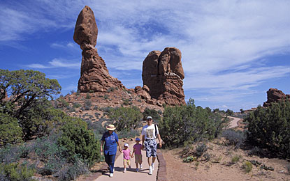
We continued on a side road past Balanced Rock towards the Garden of Eden, a large collection of monoliths. From there we continued to the Windows area, with the famous Double Arch. There is a short hike to the North, South and Turret Arches. There were so many people climbing on the arches, we couldn't get the iconic empty arch shots we wanted. We were able to take quite a few pictures though. We ate lunch there before heading over to the Double Arch trail. It was very warm and we tried out our new Camelback to stay hydrated. Tired, sunsoaked and definitely dirty, we headed into Moab in the early afternoon. Everything is outdoors- and park-oriented in Moab; most businesses are on "Main Street" which is also the main highway. We found our hotel and were able to (luckily) check in early. Mike immediately showered and felt better. Bree immediately blogged and felt better; but she showered too. After relaxing for a few hours, we decided to go out to eat.
We headed to the Moab Brewery down the street. We always try to stop at breweries as we travel; the food is always good, Mike likes beer and collects pint glasses. We had a great meal and Mike tried two of their microbeers, a Heffenweizen (Elephant Hill Heiffenweizen) and another wheat ale (Lizard something). They are famous for their "Can't Beat a Dead Horse Ale." We may eat there again while we're in town. The whole place was decorated with all the great outdoor activities you can do in the area. There were parachutes, hang gliders, rafts, bikes, etc. all hanging from the ceiling. And in great bit of marketing, each peice of gear had the contact information for the business that sells/ rents the equipment. They even had half a jeep against the wall to advertise the local jeep rentals. They also gave each customer a wooden token that was a $1 coupon towards retail merchandise.
We headed back to the hotel and have been relaxing since. "Its nice not to go to bed just because its dark out," Bree said. Mike is enjoying the flatscreen TV in our room and Bree has spent the evening finally catching up on the blog. We're currently planning tomorrow's adventure and will be going to sleep shortly.
Day 4: Capitol Reef National Park (Monday)
We woke up early and packed up our site. We weren't sure if we were going to stay in Capitol Reef another night or move on to Moab. We packed up the car and Mike let some air out of the tires to prepare for offroading. We started out on the Scenic Drive, a 10 mile road that travels deep into the park and back. We only got a few miles in before we realized that the morning light was not optimum. We turned around and headed for the offroading trail first.
On our way to the off-roading entrance we passed a few points of interest, including petroglyphs, Hickman Bridge and the Capitol Dome. The petroglyphs are ancient Native American carvings on the rock formations. They were hard to see at first as they were fairly high on the cliff and depict people and big horn sheep. Experts think that the Native peoples carved the petroglyphs to try to bring the sheep back (they were leaving due to climate change). Amazingly, some people have vandalized the area and written names beneath them. When we pulled into the parking lot to see the rest of the sights we were surprised that they weren't really there. There was a sign pointing across the street for the Capitol Dome. "It doesn't look like a dome," said Bree, but she photographed it anyway. The Hickman Bridge was a mile hike one way and since it was early enough, we decided to try it. The first 0.5 miles was the worst as it was straight uphill, about a 400 foot elevataion gain. After the first half mile, the trail wove up and down into an inner valley. We passed an older couple taking pictures in front of a low lying rock and continued past them. We ended up at Hickman's Bridge which was quite pretty. It was a hot hike, but it was nice. On the way back, we never saw the couple again, we think they thought they had found the bridge and headed back. We had a much higher view of Capitol Dome, and from that height, it did look like the Capitol Dome of a government building.
The Cathedral Valley Tour is a 60 mile off-roading trail, with washouts and a river ford. The river depth at the ford was 14", and Mike decided he could cross it. Mike loved navigating the roads and looking to avoid rocks and holes. There were some amazing views and a lot of elevation gain. We climbed way to the top for overlooks and then again way to the bottom for valley views. The whole tour was guided by a brochure from the giftstore and marked off the points of interest by mileage, our notes are added in italics.
Distances from the River Ford:
We headed back towards the campground and past it to continue the Scenic Drive. It took us about an hour and a half, with frequent stops and a few offroad trails. There was also a brochure with mile markers for this drive that we got in the giftshop. About halfway down we took the Grand Wash road to see the old uranium mines and it was part of the original road for settlers. Farther down, past some gorgeous rock formations, the Scenic Drive dead-ends at Capitol Gorge Road. We took that through the Gorge, Bree tried to take video but we were so close to such tall cliffs it was hard to take in. At the end of the Capitol Gorge Road, there was a short trail into the Gorge to see more petroglyphs and the Pioneer Register. We hiked into the gorge only about 0.25 mi to see the petroglyphs. We decided not to go in to the Pioneer Register, which is a wall that several pioneers carved their names in as they passed through the gorge. Since we were at the end of the Scenic Drive, we drove the 10 miles back towards the campground.
As we got back to the campground, we were told by two motorcyclists camped next to us that the camp host (the volunteer that lives there and monitors the campground) had moved our pay stub. There was a note that looked like a ticket attached to our parking spot. Mike went and talked to the camp host who was apparently upset that we had parked (and left our pay stub) in a different spot than we camped. We asked the motorcyclists how they could tell and they pointed to a few small numbers on the BBQ grill. We had chosen that site because it was the only open one that wasn't drenched. Although half the size of a football field, the open tent area had two large circling sprinklers. Over half the area was soaking wet as the sprinklers were on for hours. In order to get to our camp site, we had to run "the guantlet" of the two sprinklers. Setting up for dinner, we had to walk back and forth several times. Dinner was an endeavor in and of itself.
We had bought some chili and more hot dogs to cook up that night. We (luckily) had a small survival kit Mike brought that had an even smaller can opener in it. Bree was able to get it to work, and it was actually pretty handy for being so small. Since Mike had lost camp stove lighting priveleges, Bree attempted to start the stove. The winds had picked up and were quite strong. About a dozen matches later we attempted to start some kindling or paper on fire and use that. Anything we lit was blown out. We eventually walked over to the motorcyclists and asked for help. They were both quite nice and tried using a cigar lighter, that didn't work. He liked the kindling idea but took it a step further. One had a fire starting gel (Montana something or other) that he spread on the kindling, lit it really quick and stuck it in the stove. It worked! They suggested buying the gel or a "jet boil" which is apparently foolprrof no matter the weather. We're adding that to our list of stuff to buy when we hit a store (sponges, flashlight, more food, etc.) We were able to cook our hot dogs and chili on the stove, hiding it behind a tree to protect it from the wind. The chili took quite a while, Mike ate a good portion of it before it was off the stove. We also made freinds with a teacher camped next to us, also named Mike, with a cute lab mix named Bella. He was traveling from the East Coast to Idaho. He taught middle school and decided to take the huge pay cut to work in Idaho and have access to the wilderness he loved. The dog wagged its tail every time someone walked by. We also attempted to cook some Jiffy Pop, but it was burned. Bree retreated to the tent to try to type up the events of the last few days. We settled in for an early night. Tomorrow we head to Moab!
On our way to the off-roading entrance we passed a few points of interest, including petroglyphs, Hickman Bridge and the Capitol Dome. The petroglyphs are ancient Native American carvings on the rock formations. They were hard to see at first as they were fairly high on the cliff and depict people and big horn sheep. Experts think that the Native peoples carved the petroglyphs to try to bring the sheep back (they were leaving due to climate change). Amazingly, some people have vandalized the area and written names beneath them. When we pulled into the parking lot to see the rest of the sights we were surprised that they weren't really there. There was a sign pointing across the street for the Capitol Dome. "It doesn't look like a dome," said Bree, but she photographed it anyway. The Hickman Bridge was a mile hike one way and since it was early enough, we decided to try it. The first 0.5 miles was the worst as it was straight uphill, about a 400 foot elevataion gain. After the first half mile, the trail wove up and down into an inner valley. We passed an older couple taking pictures in front of a low lying rock and continued past them. We ended up at Hickman's Bridge which was quite pretty. It was a hot hike, but it was nice. On the way back, we never saw the couple again, we think they thought they had found the bridge and headed back. We had a much higher view of Capitol Dome, and from that height, it did look like the Capitol Dome of a government building.
The Cathedral Valley Tour is a 60 mile off-roading trail, with washouts and a river ford. The river depth at the ford was 14", and Mike decided he could cross it. Mike loved navigating the roads and looking to avoid rocks and holes. There were some amazing views and a lot of elevation gain. We climbed way to the top for overlooks and then again way to the bottom for valley views. The whole tour was guided by a brochure from the giftstore and marked off the points of interest by mileage, our notes are added in italics.
Distances from the River Ford:
- 9 mi Bentonite Hills - red and gray layers of rock in rounded hills; parts of it get very slick and slippery when wet.
- 14 mi Lower South Desert Overlook Spur Road - a short hike across the rock gave us a great view of the valley. Mike went to a higher point for more pictures/ videos.
- 27 mi Upper South Desert Overlook Spur Road - a short hike UPHILL gave us another view of the valley. We saw a large desert bunny as we walked up the hill.
- 27.5 mi Junction of the Hartnet/Polk Creek/Caineville Wash Roads
- 28 mi Cathedral Campground
- 30 mi Upper Cathedral Valley - We stopped for the view and ate lunch, very quickly because of the abundance of nats.
- 33 mi Junction of Caineville Wash and Baker Ranch Roads
- 33.1 mi Gypsum Sinkhole Spur Road - Mike was very excited to see this. We followed the path to see a large depression in the ground and he was dissapointed. It was quite wide but didn't seem as deep as we expected. "I kind of expected a big hole in the ground," he said. We started walking back to the car, Mike took a side trail and called out to Bree to come over to where he was. Turned out we didn't see the sinkhole. The sinkhole is over 200 feet deep and 50 feet wide. It is one very big hole in the ground and we almost missed it!
- 42.5 mi Lower Cathedral Valley Spur Road (Temples of the Sun & Moon, Glass Mountain) - The temples are actually large monolith rock formations that stand apart from the rest of the valley walls. The largest one is the Temple of the Sun, the smaller one is the Temple of the Moon and similar formations along the back wall are called the Temple of the Stars. The Glass Mountain is actually a mound of gypsum. It is totally strange because it is not only the largest single deposit of gypsum, but also has some of the largest single crystals ever seen. It sparkles in the sun and is about 15-16 feet tall!
- 60 mi Hwy 24 at Caineville Wash Road- eventually we met up with a "real" highway and started back towards camp.
We headed back towards the campground and past it to continue the Scenic Drive. It took us about an hour and a half, with frequent stops and a few offroad trails. There was also a brochure with mile markers for this drive that we got in the giftshop. About halfway down we took the Grand Wash road to see the old uranium mines and it was part of the original road for settlers. Farther down, past some gorgeous rock formations, the Scenic Drive dead-ends at Capitol Gorge Road. We took that through the Gorge, Bree tried to take video but we were so close to such tall cliffs it was hard to take in. At the end of the Capitol Gorge Road, there was a short trail into the Gorge to see more petroglyphs and the Pioneer Register. We hiked into the gorge only about 0.25 mi to see the petroglyphs. We decided not to go in to the Pioneer Register, which is a wall that several pioneers carved their names in as they passed through the gorge. Since we were at the end of the Scenic Drive, we drove the 10 miles back towards the campground.
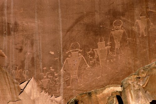
As we got back to the campground, we were told by two motorcyclists camped next to us that the camp host (the volunteer that lives there and monitors the campground) had moved our pay stub. There was a note that looked like a ticket attached to our parking spot. Mike went and talked to the camp host who was apparently upset that we had parked (and left our pay stub) in a different spot than we camped. We asked the motorcyclists how they could tell and they pointed to a few small numbers on the BBQ grill. We had chosen that site because it was the only open one that wasn't drenched. Although half the size of a football field, the open tent area had two large circling sprinklers. Over half the area was soaking wet as the sprinklers were on for hours. In order to get to our camp site, we had to run "the guantlet" of the two sprinklers. Setting up for dinner, we had to walk back and forth several times. Dinner was an endeavor in and of itself.
We had bought some chili and more hot dogs to cook up that night. We (luckily) had a small survival kit Mike brought that had an even smaller can opener in it. Bree was able to get it to work, and it was actually pretty handy for being so small. Since Mike had lost camp stove lighting priveleges, Bree attempted to start the stove. The winds had picked up and were quite strong. About a dozen matches later we attempted to start some kindling or paper on fire and use that. Anything we lit was blown out. We eventually walked over to the motorcyclists and asked for help. They were both quite nice and tried using a cigar lighter, that didn't work. He liked the kindling idea but took it a step further. One had a fire starting gel (Montana something or other) that he spread on the kindling, lit it really quick and stuck it in the stove. It worked! They suggested buying the gel or a "jet boil" which is apparently foolprrof no matter the weather. We're adding that to our list of stuff to buy when we hit a store (sponges, flashlight, more food, etc.) We were able to cook our hot dogs and chili on the stove, hiding it behind a tree to protect it from the wind. The chili took quite a while, Mike ate a good portion of it before it was off the stove. We also made freinds with a teacher camped next to us, also named Mike, with a cute lab mix named Bella. He was traveling from the East Coast to Idaho. He taught middle school and decided to take the huge pay cut to work in Idaho and have access to the wilderness he loved. The dog wagged its tail every time someone walked by. We also attempted to cook some Jiffy Pop, but it was burned. Bree retreated to the tent to try to type up the events of the last few days. We settled in for an early night. Tomorrow we head to Moab!
Day 3: Bryce Canyon & Capitol Reef National Parks (Sunday)
We woke up early and broke down camp. We attempted to make oatmeal on the camp stove but neither one us were very impressed because Bree put too much water in it. “The bowls are deceivingly large,” she says, in her defense. We left the campground and headed to Bryce Point for the early morning shots. The ampitheater that Bryce Point looks out on can also be seen from Inspiration, Sunrise and Sunset Points. We left Bryce Point, went to Paria Point and then Inspiration Point. The winds were very strong, although the skies were clear, so we were still dressed in jeans and sweatshirts. There is one main road in the park that goes several miles south to Rainbow Point and then back up with vistas and overlooks along the way. At Rainbow point we took a short hike to see some Bristlecones. Unbelievably, it was even windier at the highest point of that trail. The forest was littered with felled trees, it looked like they had been purposely chopped down. On the way back North, we stopped at each vista overlook, hopped out to take a few pictures and then back in to the car. It was cold and windy everywhere, despite being a desert. There was plenty of vegetation, and you could clearly see it change as we drove north and changed elevations. We stopped at the Sunrise/ Sunset point to hit the general store and had pizza for lunch. It was quite crowded up there as the common park visitor doesn’t make it very far into the park.
We stopped by Ruby’s Inn, a tourist trap outside the park border, and hit the general store there for supplies. It was a huge store, with kitchy souvenirs and “must have’s.” We hit the grocery section and found only some of what we needed. Surprisingly they had an adapter that allowed chargers that normally plug into the wall to plug into your car. Given all our electronic devices, we made the investment. We also bought some food but couldn’t find a sponge. After the greasy hot dogs last night, we realized that rinsing alone would not clean our dishes. No sponges available, although several different brands of dishwasher detergent were on the shelves. They had medical supplies, sleeping bags, camping gear, lawn chairs, everything you could think of, but no sponge. We did find several souvenirs that had beehives and were labeled “Utah: the Beehive State!” So we figure that’s why the highway signs have beehives on them.
We got back into the car and headed the 3.5 hours to Capitol Reef National Park. Bree took some anti-nausea medicine and promptly dosed off. Mike stopped every mile or two at vistas to catch some shots. Our poor little car got quite the workout going uphill and downhill the whole time. We pulled into Capitol Reef in the afternoon and passed several attractions (Twin Rocks, Chimney Rock, etc) on our way to the visitor center. As we stopped in, the rangers told us to hurry to get a campsite before they were all full. We did and found a nice one right by the restrooms and water. You could easily fit two cars in to each camp space and there was grass to set the tent up on. After we set up our tent we went back up to the visitor center. We got maps, looked at the exhibits and asked the rangers some questions. We had some daylight left so we headed back up the main road to see the attractions we missed. We saw Twin Rocks, Chimney Rock and the Castle, all look exactly like their namesakes. We decided to take a short hike and went to Sunset Point and took some pictures up there. It is such a great landscape, all red, orange and brown, layers and layers of rock. The layers of rock go in all directions, some crumbling, some smooth and every texture in between. As we walked along Sunset Point, Bree noticed that walking on the broken pieces of rock sounded like walking across broken plates. The top layer of rock in that area is clay, molded into large flat pieces that break into smaller pieces. From there we drove along a dirt road and took a short hike up to see the Goosenecks. Goosenecks are when twists and turns in the rivers and creeks loop so much they almost touch each other, looking like a goose’s neck. We headed back to our campsite and to make some spaghetti. As great as our campsite was, we realized it was missing some amenities. We had to pack out all trash and could not wash our dishes in the sink. We were allowed to dump “gray water” into a large washing sink but could not wash dishes in it. There were no showers and large signs that warned against washing of any kind in the bathroom. Bree ignored it and washed her hair in the sink. It dries so fast now that it is short and Bree is still surprised at how tangled it can get being only a few inches long. While Bree was illegally bathing, Mike started the camp stove, and having learned from the night before, managed to singe only the hair on one finger. Bree says he’s no longer allowed to operate the camp stove. As we were setting up camp for the night, we discovered the (rechargeable) flashlight we brought was going dead and the lantern we borrowed soon followed. So we decided to lay about in the tent, with the intention of getting up to go to a ranger talk at 9pm. Mike fell asleep at 7:30pm; Bree woke him up when it got dark out to get changed for bed and actually in a sleeping bag.
Saturday Day 2: Ely to Great Basin (Saturday)
We drove along without incident for awhile, as we were indeed in the “great basin” which is flat as far as the eye can see. There are mountains surrounding it but they are far far away. We heard a lot of thunder but only saw flashes. There was one lightning strike we could see clearly. It was several miles long and seemed to strike where the mountain range hit the road ahead of us. It was a bright flash, purple in color, and very very large! The scenery was nonexistent, we were looking for funny signs out of boredom. We noticed that all highway signs had beehives on them, we don’t know why. The signs warning of cows became normal again and we saw several more cattleguards. They seem to be across the road and continue a fence line. We don’t know what their purpose is, or how they work, we just crossed a lot of them.
The storm seemed to get worse and we saw some odd clouds in the distance. As we pulled up to a hill we could look out on a valley below. At about the same time, we turned to each other and asked, “Is that a sandstorm?!” We decided to climb a small hill to get a better view and barely made it up. We were able to lean into the wind and be held up, Mike estimated the winds to be about 70 mph. It was pouring, and with the wind, it was difficult to walk. We made it to the top to take pictures and take some brief videos. We got back in the car and were trying to decide what to do. Just about then, a large truck coming the opposite direction and flashes its high beams at us to stop. We roll down our window and the guy tells us to stop, not to go ahead, because its not worth it. He said the dust storm was so bad he barely got through it in his big truck, going half a mile an hour. He told us to hole up a while and see if it passes. By this time it was 2:30pm or so and we were worried we would have to go back to Great Basin (a few hours back) and camp there, where we were in danger of being flooded out. So we thanked him and pulled over. Mike wanted to attempt it, Bree was hesitant but Mike was driving. We agreed to drive only as far as we could see and then stop. As we drove down, we could see that the dust storm took over the whole valley. It had stopped raining in the valley but the winds were stronger. We came up behind a Sheriff’s Deputy who came out to tell us we weren’t going in there alone. He had taken over an hour to get there from Milford, only about 20 miles away. He told us to follow him, but to stay close, we were going to travel slowly. It was the most amazing experience! We could barely see the road in front of us, Mike guided the car by the quick glimpses of the white and yellow lines he could see. At times, visibility was zero, we could not see the hood of the car. The Sheriff’s lights would disappear and Mike would creep slowly forward until they could be dimly seen through the dust. Dust piled up on the windshield wipers, rearview mirrors, everything. It got eerily dark outside, Bree kept taking pictures and videos to capture it. Looking out at the landscape, when visibility improved, the whole plain looked like the moon. We passed a few cars trying to go the other way, the Sheriff would stop them and tell them to stay put until he came back for them. It took us about an hour to travel 25 miles across the valley floor until we got into Milford. When we came out of the main dust storm, there were more Sheriff’s blocking traffic going the opposite direction and several emergency crews headed back into it. The entire town was covered in dust, it looked like a thick foggy day but the sun was out, just blocked by the storm. We continued through it and when we got to the other side again, just as we saw sun, it started to rain again. We continued on our way to Bryce, still not believing we made it through. We stopped in Beaver, exchanging one highway for another and started South. There were so many trucks with big boats we figure there must be a recreation area nearby.
We finally made it to Bryce Canyon National Park, stopped at the Visitor Center and rushed down to the campground. We got one of the last spots and set up camp. After we set up our tent, we headed back up to the Visitor Center to see the exhibits and talk to the Rangers. When we talked to the Rangers, we found out that we had made it for a very special annual Astronomy-centered weekend. There were several talks going on that night that we wanted to go to, and it all capped off with 27 HUGE telescopes set up til midnight. We headed back to camp and cooked up some hot dogs on the camp stove. Mike had difficulty with lighting the camp stove because the matches kept blowing out. Somehow, when it did light, he managed to singe his eyelashes, eyebrows and the hair on his forehead. Luckily he doesn’t look too bad, you wouldn’t know it unless you looked closely. We ended up getting to the talk by the astrophotographer too late to go in so we waited around until the telescopes opened. It was cold so Bree waited in the car. Mike had brought the tripod and his camera to try to do some astrophotography of his own. The telescopes opened around 10pm and we all took turns looking through them, wandering to the next one and seeing the different set-ups. Eventually the cold got the best of us and we headed back to the tent. Bree bundled up in pants and a longsleeves and was still cold in the flannel sleeping bag with Mike! Before bed Mike tried to take some shots of the night sky from the campground, we’ll see how they turn out.
Saturday, June 20, 2009
Day 2: Rain!
We got up early, showered, got dressed in hiking apparel and walked out to see ... RAIN! Apparently the sky opened up overnight. Mike scurried to the car to get coats and we headed to continental breakfast. We met a nice man from Yuma, AZ and his granddaughter. Made for pleasant conversation over breakfast. He is way into the real estate market, we think we counted a dozen houses in four states, but still balked at our house prices. He tried to give us a DVD about a lawyer on retainer in the greater 48 states for $35 a month. Good deal if you're in real estate and have contracts to worry about, but not us. Hard bagels and yucky oatmeal made up our sustenance this morning, but hey, it was free.
Now we're packing everything back up in the car, trying to run and take refuge under the hatch door in between downpours. An old steam train just passed by so Mike is giddy.
We're moving on to Great Basin for the day and then to Bryce Canyon tonight. We'll see Bryce Canyon the next day before heading to Capital Reef. We'll probably end up staying there two nights or maybe head on to Moab. We'll be camping, so unless Mike gets an itch for a Starbucks that has WiFi, we can't post til the 23rd. Wish us luck, DRY luck! If it continues to rain we may hole up somewhere and read in the car!
No miles yet, but 270-290 miles planned!
Subscribe to:
Posts (Atom)