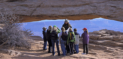
Today we got up around 8:30am and headed out to Canyonlands National Park, Island in the Sky District. There are three districts to Canyonlands National Park, the Island in the Sky in the North, the Maze to the West and the Needles to the Southeast. The districts are separated by the Colorado and Green Rivers and you cannot cross from one to the other within the park. We stopped by a local grocery store to buy food for the next few days and finally got some essentials, like a flashlight, a sponge and dishwashing detergent. We drove to Canyonlands and got to the visitor center around 10am. There is no water or any other services available in the park. It is a very rough park, not a lot of small hikes or excursions but a ton of 4x4 roads and backcountry trails. We drove along the main road (Y-shaped) and stopped at the outlooks. We did a 0.5 mi hike to Mesa Arch which was quite impressive. It is way up on a bluff and you can see the valley below it.
From there we drove down the scenic drive and stopped at more outlooks until it dead-ended at Grand View Outlook. It was a great view of part of the canyon below, Monument Basin. From there, we took a 2 mi round-trip hike along the Grand View Outlook Trail. It was a long trail but it was not too much of an elevation change, we were already pretty high up. The whole trail was right along the cliff edge across sandstone and rock outcroppings. As we followed the Cairns across the rocks we could see dark clouds coming from the southeast and could hear distant thunder. We continued on the trail, wondering when it would end since it wasn't a loop, until we came straight to a cliff. That made it obvious that this is where you turn around. We could see a large rock monolith straight in front of us and found out later that it was Junction Butte. The storm was getting closer and we were starting to see lightning so we tried to hurry back. Of course, on the way back we were tempted by the lightning and tried to get some video and stills of the lightning flashes. When we got back to the car we were pleasantly surprised that the storm had past the bluff we were on. But that whole side of the Island was dark with storm clouds.
We left the outlook and headed back to the Y in the road and headed in the other direction, away from the clouds. We stopped at a few outlooks and at the end of the road we got out to hike the Upheaval Dome. The Upheaval Dome is actually a huge crater, 2 mi across and 3/4 of a mi deep. At the bottom of the crater are "mountains," athough we don't know if they're tall enough to actually be called mountains. There were several trails available from there, one all the way around the crater, a 0.8 mi roundtrip to the first outlook and 1.8 mi to the second outlook. We headed up and at the top of the hill at the first outlook there were explanatory boards as you looked into the crater. There are two theories as to how the crater formed: meteorite vs. salt dome. The meteorite theory requires a meteorite to have fallen nearly straight down and the ground to recoil afterwards. The dome was built by the recoiling earth, it would have been eroded down into the mountains we see today. The Salt Dome theory is harder for the average visitor to take in. Layers of salt laid down by ancient seas were covered with sediments and squished under pressure. Turns out, salt is almost plastic under pressure and because it is less dense than the sediment above it started to rise and created a dome shape that pushed the sediment into the same shape above. Then the dome eroded down into the mountains. We ran into a ranger up there who told us the third theory is that it is an alien spaceship blast-off zone, or at least that's what she tells visitors. She said that was more accepting for many than the other two. She told us the second outlook wasn't too much better than the first so we decided to head back down.
From there, we headed back towards the other branch of the Y to exit past the visitor center. The entire east side of the park was dark with storms. On the way home the radio was interrupted with severe thunderstorm warnings for most of Utah. We didn't think our county was affected. When we got back to the hotel, we checked NOAA and it looks like 40% rain over the next few days from Moab to the Utah/ Arizona Border. Chance thunderstorms the whole time and when we're in Grand Canyon. We're going to have to play it by ear tomorrow. We plan on driving down to the Needles section of Canyonlands. We figure touring there won't take too long as there is little roadway that doesn't require a 4x4 jeep. From there we'll drive to the Grand Canyon and hopefully make it before the storm and/ or dark.
Subscribe to:
Post Comments (Atom)
No comments:
Post a Comment