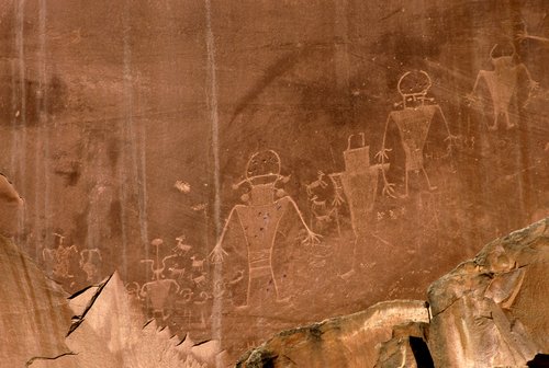
On our way to the off-roading entrance we passed a few points of interest, including petroglyphs, Hickman Bridge and the Capitol Dome. The petroglyphs are ancient Native American carvings on the rock formations. They were hard to see at first as they were fairly high on the cliff and depict people and big horn sheep. Experts think that the Native peoples carved the petroglyphs to try to bring the sheep back (they were leaving due to climate change). Amazingly, some people have vandalized the area and written names beneath them. When we pulled into the parking lot to see the rest of the sights we were surprised that they weren't really there. There was a sign pointing across the street for the Capitol Dome. "It doesn't look like a dome," said Bree, but she photographed it anyway. The Hickman Bridge was a mile hike one way and since it was early enough, we decided to try it. The first 0.5 miles was the worst as it was straight uphill, about a 400 foot elevataion gain. After the first half mile, the trail wove up and down into an inner valley. We passed an older couple taking pictures in front of a low lying rock and continued past them. We ended up at Hickman's Bridge which was quite pretty. It was a hot hike, but it was nice. On the way back, we never saw the couple again, we think they thought they had found the bridge and headed back. We had a much higher view of Capitol Dome, and from that height, it did look like the Capitol Dome of a government building.
The Cathedral Valley Tour is a 60 mile off-roading trail, with washouts and a river ford. The river depth at the ford was 14", and Mike decided he could cross it. Mike loved navigating the roads and looking to avoid rocks and holes. There were some amazing views and a lot of elevation gain. We climbed way to the top for overlooks and then again way to the bottom for valley views. The whole tour was guided by a brochure from the giftstore and marked off the points of interest by mileage, our notes are added in italics.
Distances from the River Ford:
- 9 mi Bentonite Hills - red and gray layers of rock in rounded hills; parts of it get very slick and slippery when wet.
- 14 mi Lower South Desert Overlook Spur Road - a short hike across the rock gave us a great view of the valley. Mike went to a higher point for more pictures/ videos.
- 27 mi Upper South Desert Overlook Spur Road - a short hike UPHILL gave us another view of the valley. We saw a large desert bunny as we walked up the hill.
- 27.5 mi Junction of the Hartnet/Polk Creek/Caineville Wash Roads
- 28 mi Cathedral Campground
- 30 mi Upper Cathedral Valley - We stopped for the view and ate lunch, very quickly because of the abundance of nats.
- 33 mi Junction of Caineville Wash and Baker Ranch Roads
- 33.1 mi Gypsum Sinkhole Spur Road - Mike was very excited to see this. We followed the path to see a large depression in the ground and he was dissapointed. It was quite wide but didn't seem as deep as we expected. "I kind of expected a big hole in the ground," he said. We started walking back to the car, Mike took a side trail and called out to Bree to come over to where he was. Turned out we didn't see the sinkhole. The sinkhole is over 200 feet deep and 50 feet wide. It is one very big hole in the ground and we almost missed it!
- 42.5 mi Lower Cathedral Valley Spur Road (Temples of the Sun & Moon, Glass Mountain) - The temples are actually large monolith rock formations that stand apart from the rest of the valley walls. The largest one is the Temple of the Sun, the smaller one is the Temple of the Moon and similar formations along the back wall are called the Temple of the Stars. The Glass Mountain is actually a mound of gypsum. It is totally strange because it is not only the largest single deposit of gypsum, but also has some of the largest single crystals ever seen. It sparkles in the sun and is about 15-16 feet tall!
- 60 mi Hwy 24 at Caineville Wash Road- eventually we met up with a "real" highway and started back towards camp.
We headed back towards the campground and past it to continue the Scenic Drive. It took us about an hour and a half, with frequent stops and a few offroad trails. There was also a brochure with mile markers for this drive that we got in the giftshop. About halfway down we took the Grand Wash road to see the old uranium mines and it was part of the original road for settlers. Farther down, past some gorgeous rock formations, the Scenic Drive dead-ends at Capitol Gorge Road. We took that through the Gorge, Bree tried to take video but we were so close to such tall cliffs it was hard to take in. At the end of the Capitol Gorge Road, there was a short trail into the Gorge to see more petroglyphs and the Pioneer Register. We hiked into the gorge only about 0.25 mi to see the petroglyphs. We decided not to go in to the Pioneer Register, which is a wall that several pioneers carved their names in as they passed through the gorge. Since we were at the end of the Scenic Drive, we drove the 10 miles back towards the campground.
As we got back to the campground, we were told by two motorcyclists camped next to us that the camp host (the volunteer that lives there and monitors the campground) had moved our pay stub. There was a note that looked like a ticket attached to our parking spot. Mike went and talked to the camp host who was apparently upset that we had parked (and left our pay stub) in a different spot than we camped. We asked the motorcyclists how they could tell and they pointed to a few small numbers on the BBQ grill. We had chosen that site because it was the only open one that wasn't drenched. Although half the size of a football field, the open tent area had two large circling sprinklers. Over half the area was soaking wet as the sprinklers were on for hours. In order to get to our camp site, we had to run "the guantlet" of the two sprinklers. Setting up for dinner, we had to walk back and forth several times. Dinner was an endeavor in and of itself.
We had bought some chili and more hot dogs to cook up that night. We (luckily) had a small survival kit Mike brought that had an even smaller can opener in it. Bree was able to get it to work, and it was actually pretty handy for being so small. Since Mike had lost camp stove lighting priveleges, Bree attempted to start the stove. The winds had picked up and were quite strong. About a dozen matches later we attempted to start some kindling or paper on fire and use that. Anything we lit was blown out. We eventually walked over to the motorcyclists and asked for help. They were both quite nice and tried using a cigar lighter, that didn't work. He liked the kindling idea but took it a step further. One had a fire starting gel (Montana something or other) that he spread on the kindling, lit it really quick and stuck it in the stove. It worked! They suggested buying the gel or a "jet boil" which is apparently foolprrof no matter the weather. We're adding that to our list of stuff to buy when we hit a store (sponges, flashlight, more food, etc.) We were able to cook our hot dogs and chili on the stove, hiding it behind a tree to protect it from the wind. The chili took quite a while, Mike ate a good portion of it before it was off the stove. We also made freinds with a teacher camped next to us, also named Mike, with a cute lab mix named Bella. He was traveling from the East Coast to Idaho. He taught middle school and decided to take the huge pay cut to work in Idaho and have access to the wilderness he loved. The dog wagged its tail every time someone walked by. We also attempted to cook some Jiffy Pop, but it was burned. Bree retreated to the tent to try to type up the events of the last few days. We settled in for an early night. Tomorrow we head to Moab!
No comments:
Post a Comment